

BOZEMAN – A weak disturbance along with a cold front will produce areas of snow Sunday afternoon through Monday morning.
This is the first of two storms to impact SW Montana over the next 3 days. The second storm will produce additional snow and possible travel impacts Tuesday.

The National Weather Service did issue a WINTER WEATHER ADVISORY Sunday evening through Monday morning for all counties in SW Montana. This includes Butte, Bozeman, Dillon, and West Yellowstone and all areas between.
NWS snowfall forecast is for 1”-3” down in most valleys with 4”-8” over mountains and passes. Watch for pockets of valley rain, freezing rain, and wet roads turning icy overnight into Monday morning. Mountain passes are also wet Sunday afternoon and with additional snow and colder temperatures overnight watch for very icy roads by Monday morning.
NEXT WEATHER MAKER
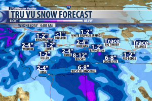
The next weather maker will arrive Monday night into Tuesday morning. This storm will have deeper moisture and could be a slower moving storm. That means a better chance for accumulating snow. Mountain passes on the MT/ID state line like: Lookout, Lolo, Lost Trail, Monida, Raynolds, and Island Park, ID could see 6”-12” of snow Monday night through Wednesday morning.
Other mountain passes in SW Montana will see periods of moderate snow Monday night into Tuesday and lower valleys could see minor accumulations of snow.
TEMPERATURE SPIKE
Ahead of a stronger cold front a good push of warm air will roll up into Montana with well above normal temperatures by the end of the week into the next weekend. Temperatures could be climbing up to the lower 50’s for some (not all) lower valleys in SW Montana.
Although a spring like pattern sounds great it should be short lived. The aforementioned cold front will drop temperatures back down to normal levels by the first week in February.
