BUTTE – The National Weather Service has issued a WIND ADVISORY for the Butte/Blackfoot region Saturday 3 pm to midnight.
Areas of greatest concern will be between Drummond to Deer Lodge and up to MacDonald Pass. This region of Granite and Powell counties could see sustained winds out of the NE 20 to 30 mph and gusts at times up to 45 mph. 3 pm to 9 pm will be the time frame for the strongest winds.
Property damage and power outages are possible if wind gusts reach 50 mph.
As of 2 pm Friday no additional advisories have been issued for SW Montana. However, look for increasing surface winds across the entire state Saturday ahead of the next weather maker arriving Saturday evening into Sunday morning.

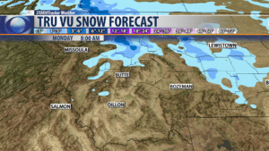
Next weather maker will arrive Saturday night into Sunday and as of Friday afternoon forecast models show there is a better chance for rain and snow impacting NW and central Montana.
Snow is likely again along the rocky mountain front and up toward Glacier National Park. For SW Montana there is only a slight chance for measurable mountain snow this weekend. Another shot of colder air will push down into the entire state Sunday.
City by City Forecast:
BOZEMAN: LOW: 35°; HIGH SATURDAY: 57°. Partly cloudy and breezy Friday night and Saturday should be mostly dry but watch for increasing clouds and increasing surface winds late in the day.
BUTTE: LOW: 32°; HIGH SATURDAY: 56°. A frosty night likely for Butte and breezy. Saturday should be dry with increasing clouds and very strong late day winds 15 to 25 mph and gusts over 30 mph out of the NE.
DILLON: LOW: 35°; HIGH SATURDAY: 63°. Cool and breezy Friday night Dillon and Saturday more of the same. Look for stronger afternoon winds 10 to 20 mph.
WEST YELLOWSTONE: LOW: 27°; HIGH SATURDAY: 66°. Clear and frosty tonight for West Yellowstone but look for mild afternoon highs in the 60s. Afternoon surface winds are likely to increase as well.
