

BUTTE, Mont: The beginning of a cool and wet weather pattern has arrived and there will be numerous rounds of off and on rain or snow for the valleys and moderate wet snow impacting travel over mountain passes tonight through early next week.
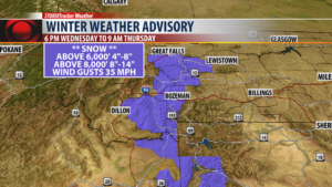
The National Weather Service has issued a WINTER WEATHER ADVISORY for Madison, Gallatin, Broadwater and Meagher counties above 6,000′. Possible snow accumulations of 4″-8″ will impact Kings Hill pass, Bozeman pass, Norris Hill, Raynolds pass and Targhee pass along with Big Sky and West Yellowstone.
Above 8,000′ a foot of wet heavy snow is possible tonight.
HALLOWEEN FORECAST:
Unfortunately the forecast is still calling for cool and wet conditions tonight and will impact most trick or treating in SW Montana.
City by City Forecast:
BOZEMAN: LOW: 33°; HIGH THURSDAY: 48°. Scattered valley and mountain snow this evening into Thursday morning. Snow levels could fall down to 5,500′ tonight and above 6,000′ there could be 4″-8″ of snow overnight impacting travel over Bozeman pass. Thursday look for off and on showers but another big push of moisture is likely Thursday evening with more valley rain and mountain and possible travel impacts by Friday morning.
BUTTE: LOW: 31°; HIGH THURSDAY: 48°.Scattered rain or snow is likely this afternoon and evening for Butte. 1″-2″ of snow could accumulate overnight but will melt away by Thursday afternoon. A few off and on showers are likely Thursday with another big push of moisture coming Thursday evening into Friday morning. Homestake pass and Elk Park pass will see wet slushy snow, possible icing and gusty winds tonight through Friday.
DILLON: LOW: 31°; HIGH THURSDAY: 47°. Scattered rain is likely this afternoon and evening but could mix with snow overnight. Snow levels to fall down to 6,500′ with 5″-8″ possible for Monida pass and Big Hole pass into Thursday morning. Another round of valley rain and mountain snow will impact your region Thursday evening into Friday morning.
WEST YELLOWSTONE: LOW: 23°; HIGH THURSDAY: 39°. Look for increasing rain changing to snow tonight. Snow levels to fall down to 5,500′ and 4″-8″ is possible overnight. This will impact travel in West Yellowstone and for Raynolds pass and Targhee pass overnight. Gusty winds at times could reduce visibility. Another round of wet weather to impact your area Thursday afternoon through Friday morning.
