BUTTE – Harsh winter weather will continue to impact Montana over the next couple of days. Cold dense Arctic air is sitting down at the surface and moist pacific air is moving up from the SW.
As these two air masses collide it will produce more snow, wind, blowing snow and extremely cold wind chills through Tuesday evening.
Once the snow begins to diminish and skies clear heading into Wednesday much colder lows are likely in SW Montana.
THE NEXT WEATHER MAKER:
Low pressure over Northern California will send another shot of moisture up into Montana by Tuesday morning. Increasing snow and wind will bring another round of hazardous travel impacts.
Snow banding will produce off and on periods of snow Tuesday into Wednesday morning.
WINTER WEATHER ADVISORY:
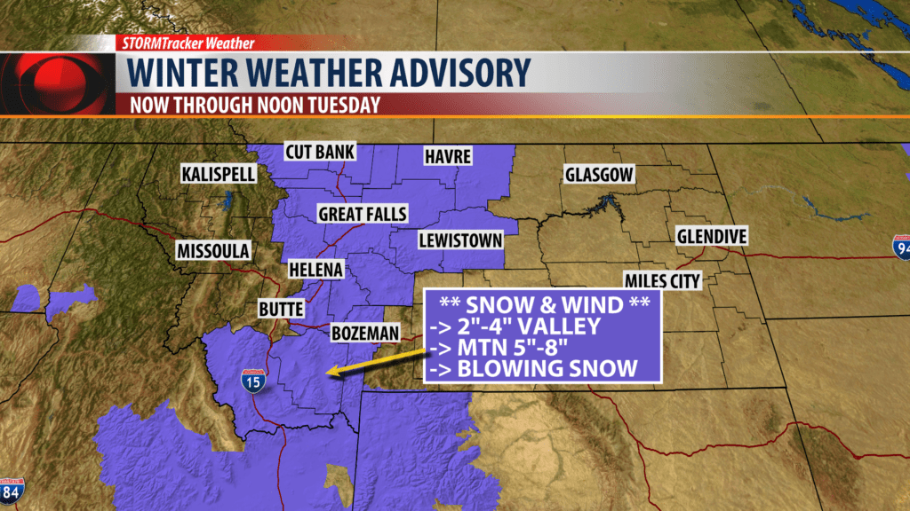
The National Weather Service has a Winter Weather Advisory up for SW Montana now through noon Tuesday.
Snow accumulations: Valleys 2″-5″ and Mountains 4″-8″ are possible.
Travel Impacts: Snow covered and icy roads with patchy areas of blowing and drifting snow and lower visibility. Very difficult to hazardous travel especially over mountain passes.
AVALANCHE WARNING:
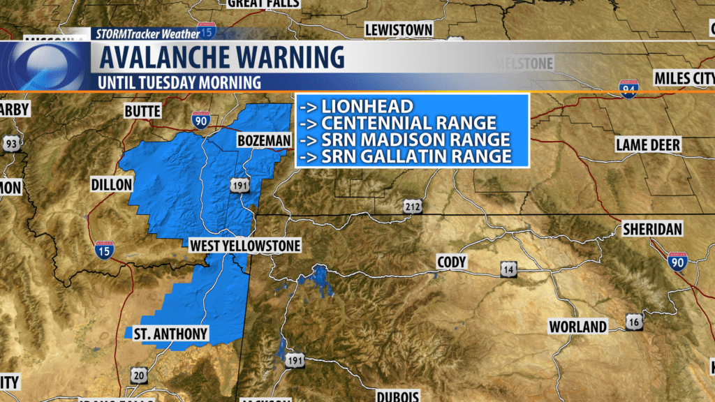
The Gallatin National Forest Avalanche Center issued a Backcountry Avalanche WARNING for the Lionhead area near West Yellowstone, the Centennial Range, Southern Madison Range and Southern Gallatin Range into Tuesday morning.
Heavy snow and wind loading hit this area on Sunday. Natural and human triggered avalanches are likely. Avalanche terrain and avalanche run out zones should be avoided. The avalanche danger is rated HIGH on all slopes.
WIND CHILL:
There are Wind Chill Warnings and Wind Chill Advisories up across Montana heading into Monday evening. These highlights will likely change later this afternoon so look for updates on KBZK.com and on the KBZK STORMTracker Weather mobile app.
City by City Forecast:
BOZEMAN: LOW: -2°; HIGH TUESDAY: 12°. Mostly cloudy tonight with increasing snow likely by morning. Snow is likely Tuesday with 3″-6″ possible. NE surface winds to 15 mph will continue to produce bitter below zero wind chills and localized areas of blowing and drifting snow.
BUTTE: LOW: -1°; HIGH TUESDAY: 11°. Partly cloudy early with increasing clouds overnight. Snow is likely as well Tuesday morning into Tuesday afternoon. Snow accumulations of 1″-3″ is possible with over 3″ for nearby mountain passes. NE winds to 15 mph will keep wind chills below zero and could produce some blowing snow.
DILLON: LOW: 2°; HIGH TUESDAY: 20°. Mostly cloudy overnight and cold. SE winds to 15 mph will continue and produce bitter below zero wind chills and some blowing snow. Snow will increase by morning. Snow accumulations of 2″-5″ is possible for Dillon and 5″-8″ for nearby mountain passes.
WEST YELLOWSTONE: LOW: 12°; HIGH TUESDAY: 26°. The deep Arctic air over Montana is stalling just North of West Yellowstone so your temperatures will be some of the warmer temperatures again tonight into Tuesday. Next weather maker will bring another shot of snow your way by Tuesday morning. Snow could be heavy at times. Snow accumulations of 4″-6″ is possible and higher amounts over nearby mountains and passes.
