BUTTE – Atmospheric river of moisture extending south of Hawaii is transported up into Oregon, Idaho, and Southern Montana. At the same time, cold Arctic air covers the state. This clashing of air masses is what we call an “over-running” storm event and has great potential for producing widespread and heavy snowfall.
This pattern continues this evening through Wednesday morning. More snow and wind will continue to impact travel at all levels and areas of blowing and drifting will add to the dangerous impacts of traveling.
__________________________________________________________________________________________________
WINTER STORM WARNING:

The National Weather Service continues a WINTER STORM WARNING from Missoula to Miles City and from Monida to Great Falls to Lewistown through Tuesday late morning west of the divide and through Tuesday evening east of the divide.
Snow heavy at times will impact much of southern and central Montana along with localized wind gusts over 30 mph that will produce blowing and drifting snow.
_______________________________________________________________________________________________
AVALANCHE WARNING:

The Gallatin National Forest Avalanche Center continues a backcountry avalanche WARNING for the Lionhead area near West Yellowstone and the Centennial mountain range.
Wind loading is creating very dangerous backcountry avalanche conditions and natural and human triggered avalanches are likely.
Avoid avalanche terrain and runout zones. Avalanche danger is rated “HIGH” on all slopes.
_________________________________________________________________________________________________
SEVERE DRIVING CONDITIONS:

As of 1 pm Monday the Montana Department of Transportation has “Severe Driving Conditions” up for I-90 from Fairmount Hot Springs to Warm Springs and for Highway 1 from Anaconda to Georgetown Lake.
Considerable areas of blowing snow are producing reduced visibility making for dangerous travel.
_________________________________________________________________________________________________
ROAD CLOUSRES:
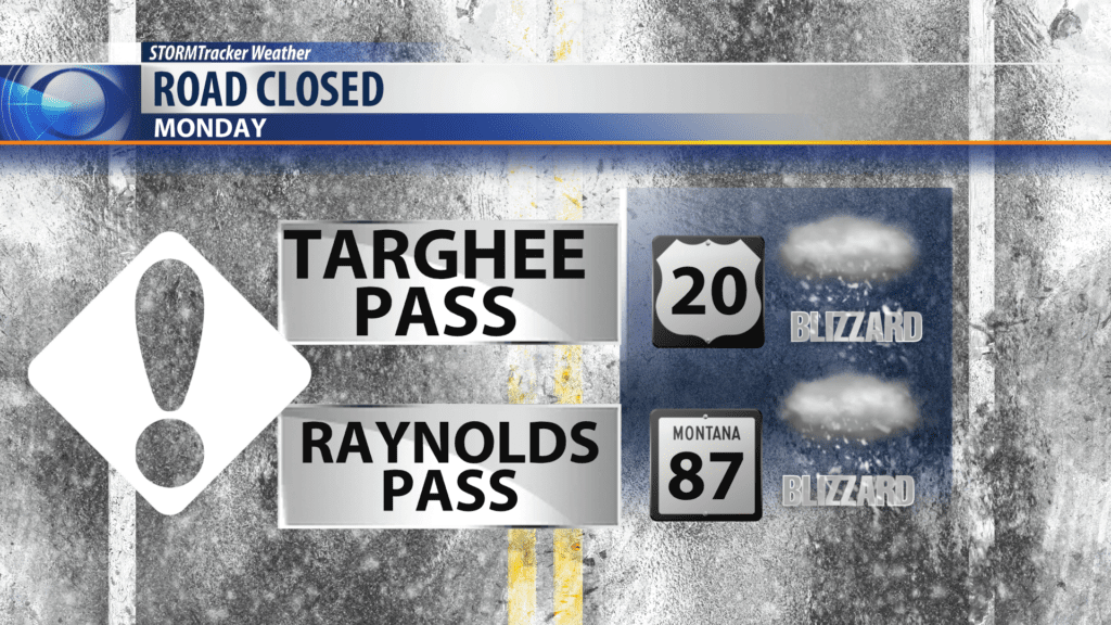
Roads going into Island Park, ID is CLOSED! Blizzard conditions started Sunday morning on the Idaho side of Raynolds Pass and Targhee Pass.
______________________________________________________________________________________________
SNOW REPORTS:

These are preliminary reports of snow so far across SW Montana. These numbers will increase as snow continues to impact SW Montana. Please send us your storm reports and photos to: newstips@kbzk.com.
