

BOZEMAN – There are two concerns in the short term forecast for SW Montana. First, rising river levels and second strong thunderstorms.

The National Weather Service did issue a FLOOD ADVISORY for the Gallatin River through 2:30 pm Tuesday.
Rivers levels have reached “action” stage or just below minor flood stage on the Gallatin River. Rapid snowmelt is the cause of the rising levels and if thunderstorms develop Monday afternoon there could be some locally heavy rain.
Lowland flooding is possible along the Gallatin River.
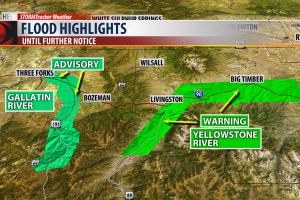
The National Weather Service issued a FLOOD WARNING for the Yellowstone River through Livingston until further notice.
River levels have barely crested above minor flood stage Monday. River levels will continue to oscillate throughout the week and cresting near Livingston around 10.4’ Tuesday and Wednesday with a minor flood stage at 10’.
SW flow aloft and stronger surface heating will produce an unstable atmosphere Monday afternoon and early evening. There will likely be several thunderstorms passing through SW Montana and some could be strong with one or two storms turning severe.
Brief heavy rain, small to large hail, and strong possibly damaging wind gusts are possible between 3 pm and 2 am east of the divide in SW Montana.

The Storm Prediction Center has a “marginal” risk out for strong to severe thunderstorms from Three Forks eastward to Billings up to Lewistown. Bozeman and Belgrade could see a few stronger thunderstorms Monday afternoon and evening.
