


Today's Forecast:
Southwest Montana will remain under a cool and unsettled weather pattern today with widespread clouds, scattered showers and periods of thunderstorms developing through the afternoon and evening. Air quality conditions continue to improve compared to last week, although isolated pockets of lingering wildfire smoke may still be noticeable. Afternoon winds will become breezy at times, especially near thunderstorms where gusty and erratic winds are possible.
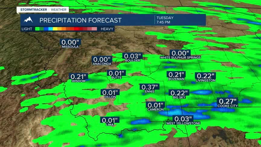
BOZEMAN: High: 78; Low: 53. Mostly cloudy skies with patchy smoke possible early this morning. Showers and thunderstorms become more widespread this afternoon and evening, with periods of moderate rainfall possible. East southeast winds around 5 to 10 mph this afternoon. Wet conditions continue tonight with scattered showers lingering overnight.
BUTTE: High: 78; Low: 49. Mostly cloudy with scattered showers developing through the day. Thunderstorms become possible this afternoon and evening with brief heavy rain and gusty winds possible near stronger storms. North to northwest winds increase between 10 and 15 mph this afternoon. Cooler temperatures continue tonight with lingering showers possible overnight.
DILLON: High: 79; Low: 50. Mostly cloudy with isolated showers early, followed by increasing chances for showers and thunderstorms this afternoon and evening. Southwest winds increase to around 10 to 15 mph during the afternoon hours. Cooler temperatures and higher humidity continue tonight with scattered showers lingering overnight.
WEST YELLOWSTONE: High: 74; Low: 42. Cloudy skies with scattered showers developing through the day and thunderstorms possible during the afternoon and evening hours. Southwest winds increase between 10 and 20 mph with occasional higher gusts possible near storms. Cooler conditions continue tonight with showers lingering into the overnight period.
SLIGHT WARM-UP MID-WEEK
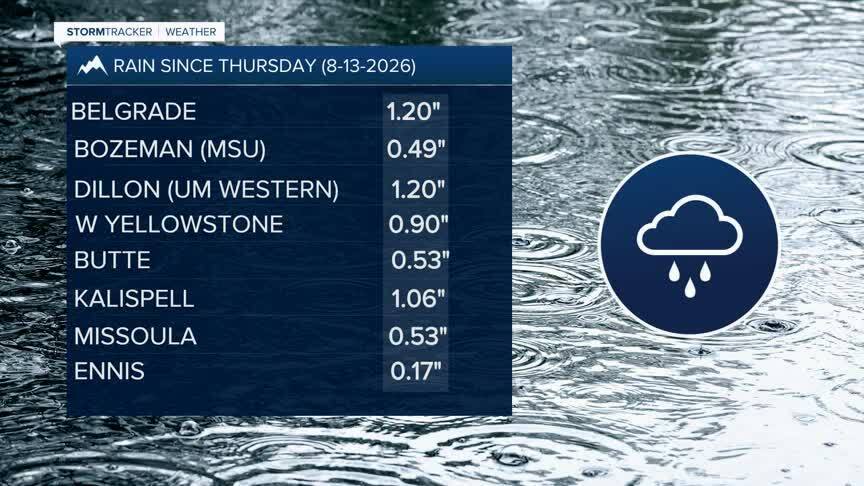
A much cooler and wetter weather pattern remains in place across southwest Montana through Tuesday. Periods of showers and thunderstorms are expected daily through Tuesday, with locally heavy rainfall and gusty winds possible at times. Fire danger and smoke concerns will continue where they are now until Tuesday evening. We do see a warming trend Wednesday through Friday with highs pushing into the 80s and low 90s. We will likely pick up more smoke during that time and we will see fewer rain chances until Friday evening with the current weather trends.
