


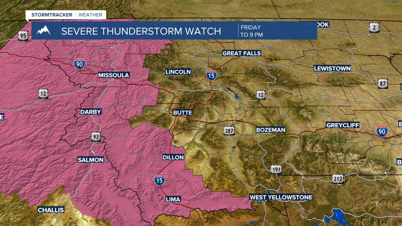
UPDATE: The National Weather Service issued a SEVERE THUNDERSTORM WATCH for the far western counties of Montana through 9 pm Friday evening. This means damaging thunderstorms are possible with wind gusts up to or over 60 mph and/or hail up to 1" or larger in diameter. Heavy rainfall is also possible along with frequent lightning. The watch includes Beaverhead and Granite Counties in SW Montana.
_______________________________________________________________________________________________________________________________________________
BOZEMAN – Thunderstorms are likely to sweep across SW Montana Friday afternoon into the early evening hours. Some storms could be strong and maybe 1 or 2 could be severe.
The Storm Prediction Center has central Idaho and far western Montana under a “slight” risk for possible damaging thunderstorms Friday afternoon into Friday evening. Some storms could produce damaging wind gusts and/or damaging hail. The other issue is plenty of lightning and possible new wildfires.

SW Montana is in a lower risk category or what the SPC calls a “moderate” risk for possible damaging thunderstorms Friday afternoon and evening. Although the threat for damaging thunderstorms is lower there certainly could be a few strong thunderstorms and maybe 1 or 2 severe thunderstorms.
I will be waiting for updates from the National Weather Service to see if any severe thunderstorms watches are issued. Stay tuned.
Saturday the thunderstorm threat moves from central Idaho into SW Montana east of the divide. Again, the Storm Prediction Center has a “marginal” risk for strong to severe thunderstorms over a very small area locally, roughly from Bozeman eastward.

Thunderstorms Saturday are likely to develop over southern Beaverhead County and lift to the NE and strengthen over Madison, Gallatin, and Park counties Saturday afternoon and evening. After 3 pm is the best time for storms to develop Saturday.
Sunday should be slightly cooler and thunderstorms are not expected with just a few mountain based rumbles likely near West Yellowstone.
Next week look for temperatures to rise above normal with most lower valleys likely to reach the low to mid 90s.
