BOZEMAN – Active weather pattern will impact Montana, Idaho, and Wyoming through the Friday. A strong westerly flow aloft is pushing warm moist storms into the Pacific NW and Northern Rockies Thursday through Friday.
This type of a weather pattern favors classic upslope region along the MT/ID state line for areas of moderate to heavy snow and travel impacts for Lookout, Lolo, Lost Trail passes.
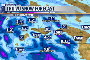
A secondary bullseye for upslope snow will be Yellowstone National Park and surrounding areas like West Yellowstone, Cooke City, and Island Park, ID.
The rest of SW Montana will see off and on mountain snow showers with minor impacts on travel over all local area mountain passes with 1” – 6” of snow, wet roads turning icy overnight, and localized pockets of lower valley freezing rain.
Another impact of a strong jet stream aloft is stronger surface winds especially in wind prone areas. This could help dry out the lower levels but at times snow and strong winds could produce areas of blowing snow.
The weather pattern will begin to improve by Saturday as colder but stable air moves back into Montana.
WINTER WEATHER HIGHLIGHTS
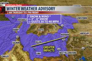
The National Weather Service has issued WINTER WEATHER ADVISORY for Beaverhead, Madison, Gallatin counties from 2 am Thursday to 5 pm Friday.
Areas of greatest concern: Dillon to Bozeman southward. Moderate to heavy snow is possible from Big Sky to West Yellowstone, Targhee and Raynolds passes. Snow accumulations of 3” – 6” are possible along with wind gusts 20 to 30 mph.
Bozeman and Bozeman pass will see off and on rain or snow showers Thursday into Friday but wet roads will turn icy for your Friday morning and Friday evening commutes and possibly for Thursday evening commutes.
WINTER STORM WARNING

The National Weather Service issued a WINTER STORM WARNING for Yellowstone National Park, Island Park, ID and for the Absaroka Beartooth wilderness areas near Cooke City Wednesday night through Friday night.
West facing slopes could see 12” – 18” of snow.
Wind gusts 30 to 50 mph are possible at times.
Both will likely bring increased avalanche danger especially with wind loaded slopes.

Other travel impacts will be along the MT/ID state line including I-90 from Missoula to Spokane, WA. Lookout Pass could see around a foot of snow. Missoula to Lookout Pass watch for rain and pockets of freezing rain, as well as, from Missoula to Kalispell. On the Idaho side of Lookout Pass 1 to 2 feet of snow is possible along with wind gusts 20 to 40 mph. Lost Trail and Lolo passes will see snow and wind and difficult to hazardous travel conditions.