

BOZEMAN – A blast of winter weather will impact Montana tonight through Friday afternoon.
The tail end of yesterday’s cold front continues to produce areas of snow mostly across southern Montana today.
That system moves out tonight,and we will be briefly between storm systems Wednesday. By Wednesday night into Thursday the next winter like storm arrives with increasing snowfall for valleys and mountains by Thursday afternoon through Friday morning.
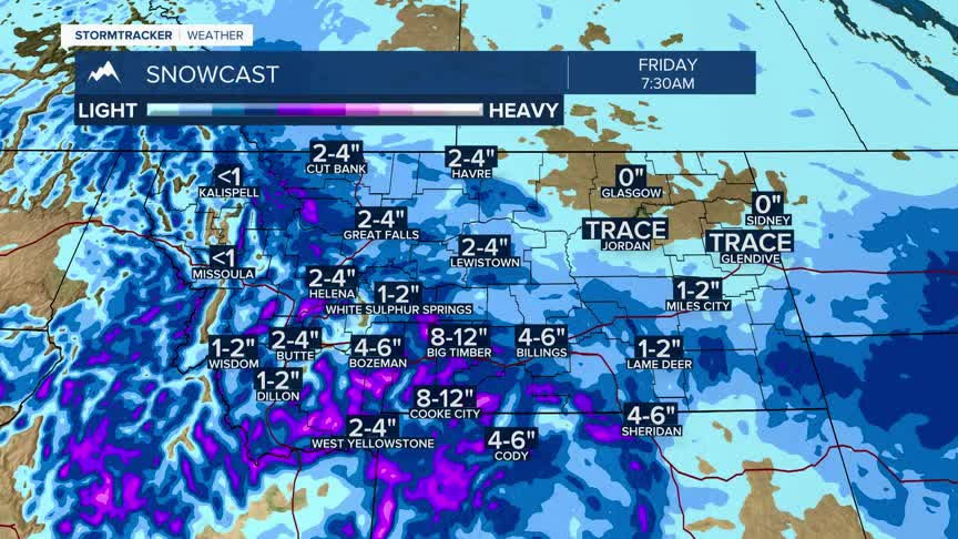
Accumulating snow is likely at all levels so be prepared for slow-go wintry travel condition Thursday into Friday.All of this active weather will begin to exit the region by Saturday with warming and drying by Sunday.
The National Weather Service has issued a WINTER STORM WATCH from Thursday morning through Friday morning, and this watch will likely see an upgrade to a warning soon.
West of the divide in the Butte/Blackfoot region above 5,500’ 6”-12” of heavy and very wet snow is possible along with wind gusts to35 mph. Below 5,500’ 2”-6” of snow is possible from this storm.
East of the divide snow is expected to be heavy at times above 5,000’ with 8”-12” possible and higher amounts for the tallest peaks. Localized wind gusts to 40 mph is expected with possible areas of blowing snow impacting travel conditions, especially Thursday afternoon and evening.
