

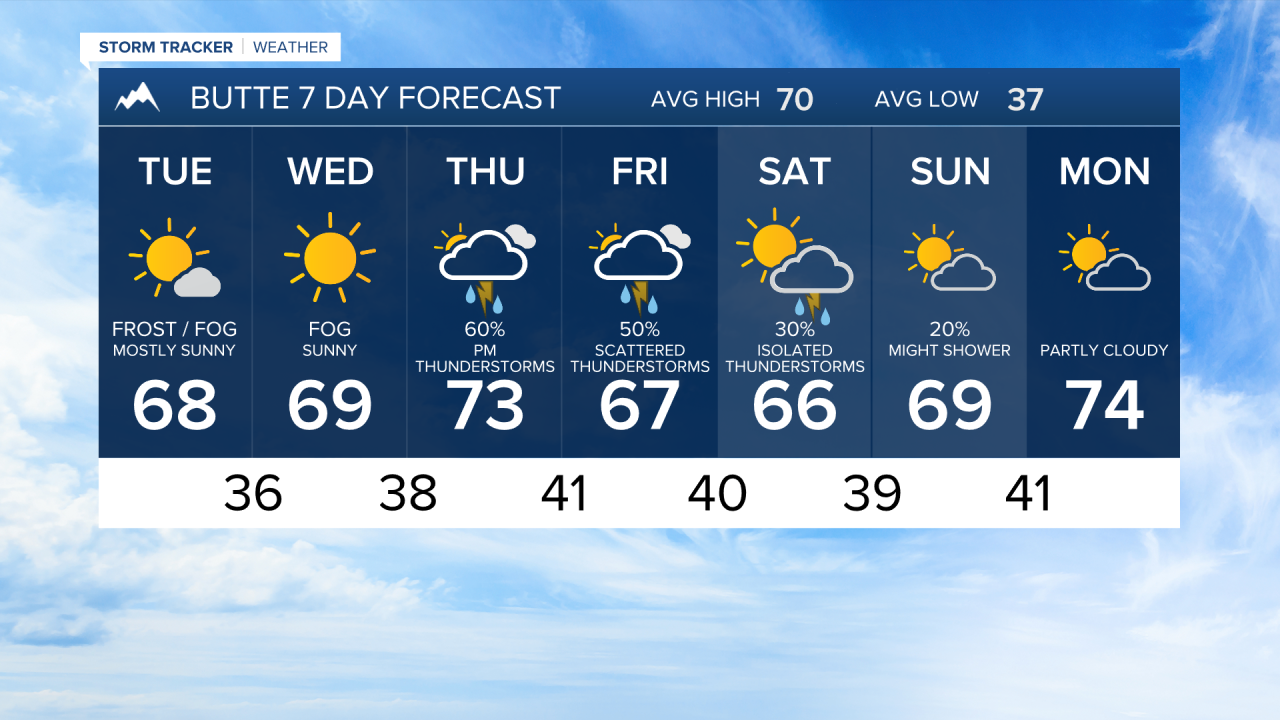


BUTTE — A cool and somewhat unsettled start to the week will gradually transition toward warmer temperatures and increasing chances for showers and thunderstorms later this week across southwest Montana, including Butte, Bozeman, Dillon, Ennis, and West Yellowstone.
MONDAY NIGHT
A few lingering showers remain possible this evening as the departing storm system continues to move east. Skies gradually clear overnight, winds ease, and temperatures turn chilly. Overnight lows will fall into the 30s in many valleys, including around Butte and West Yellowstone, with upper 30s and 40s common around the Gallatin Valley and Livingston. Frost and fog are possible, and you have want to cover remaining plants.
TUESDAY
High pressure briefly settles over southwest Montana, bringing a quieter and generally drier day. Expect a mix of sunshine and clouds with seasonably cool temperatures. Highs reach the upper 60s to lower 70s for Bozeman, Dillon, and Butte. A stray mountain shower cannot be ruled out, but most communities stay dry.
WEDNESDAY
The ridge remains in control, providing another relatively pleasant day. Temperatures stay near or slightly below average with highs mostly in the upper 60s and lower 70s. While most of southwest Montana remains dry, isolated showers are still possible, especially over the higher terrain during the afternoon and evening.
THURSDAY
The weather pattern begins to shift as the next upper-level disturbance approaches from the west. Clouds increase through the day, and scattered showers and thunderstorms develop during the afternoon and evening. Southwest Montana stands among the favored areas for rainfall later this week. Temperatures begin a warming trend, with many lower elevations climbing into the 70s.
FRIDAY
This appears to be the most active period of the forecast. Widespread showers and scattered thunderstorms are expected across southwest Montana, with the highest thunderstorm chances occurring from midday Friday through Friday evening. Areas around Butte, Bozeman, Dillon, and the surrounding mountain ranges could see periods of beneficial rainfall. High temperatures remain mild, generally in the 70s.
SATURDAY
Showers and thunderstorms continue as the storm system moves through the Northern Rockies. Rainfall probabilities remain elevated across southwest Montana, and current indications suggest the southern half of the region has one of the better chances of receiving meaningful precipitation. Expect a mix of clouds, showers, and occasional breaks of sunshine with highs mainly in the lower to middle 70s.
SUNDAY
Conditions improve as a building ridge of high pressure returns. Showers taper off, skies gradually become sunnier, and temperatures warm further. Southwest Montana should enjoy a mostly dry day with highs reaching the mid to upper 70s, providing a pleasant finish to the weekend.
LOOKING AHEAD
The warming trend continues into early next week as high pressure strengthens over the Northern Rockies. Expect warmer afternoons, mainly dry weather, and increasingly comfortable conditions across southwest Montana, including Butte, Bozeman, Dillon, and surrounding valleys.
